
Cliff Beach
Chapel Porth
A rugged Atlantic cove beneath towering cliffs and mining history — where surf, dark rock, wild seas and Cornwall's industrial coastline meet dramatically.
The Coastal Experience
What Chapel Porth Is Actually Like
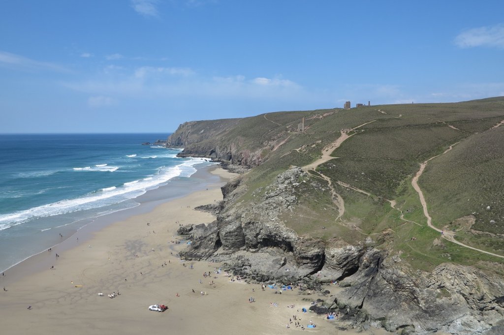
Chapel Porth feels shaped by both the Atlantic and Cornwall's mining past. Dark cliffs, rough textures and the remains of the industrial coastline give the cove a stronger and more elemental atmosphere than many nearby beaches.
The beach itself changes dramatically with the tide. Lower tides reveal more sand and rock formations, while high tide compresses the cove tightly beneath the cliffs.
The surrounding landscape feels rugged rather than polished. Atlantic weather moves visibly across the coastline while old mining features remain scattered through the cliffs above.
The South West Coast Path climbs directly from the cove into some of North Cornwall's most dramatic walking country.
Current conditions & location
This morning at Chapel Porth




Weather
☁️ Overcast
16°C (feels like 13°C)
Moderate wind from the SW
14% chance of rain
Today: 18°C / 15°C
Tides today
Today's tide at Chapel Porth is building from low water. For this beach, lower tides reveal more sand, rock formations and access to the surrounding shoreline. high tide can dramatically compress the beach and intensify the atlantic atmosphere beneath the cliffs.. Conditions now are overcast, moderate wind from the SW, 16°C.
Met Office forecast updated every 30 minutes. Tide times are modelled estimates — confirm with local tide tables before swimming or crossing tidal ground.
Who Is This Place For?
Select your visit style to see what to expect.
Preparation
Useful for this beach
Based on what this location offers and what visitors typically find helpful.
Rockpooling
- Old trainers or beach shoes — rocks are slippery
- Small bucket for a closer look
- Best explored at or near low tide
Surfing
- Wetsuit appropriate to the season
- Board wax if you know the water temperature
- Towel or changing robe
- Check flag colours and tide before paddling out
Photography
- Spare battery — cold and salt air drain them faster
- Lens cloth for sea spray
- Check the tide and light direction before you set up
Wildlife watching
- Binoculars if you have them
- Soft-soled footwear — quieter on rock and shingle
- Keep well back from nesting birds and resting seals
Wind exposure
- A windproof layer — this beach catches prevailing winds
- Secure bags and towels before you put them down
Water & Safety
Know Before You Go
Lifeguards
RNLI lifeguard patrols may operate seasonally during peak visitor periods. Check local signage for current coverage.
RNLI Information
Visitors entering the water should assess conditions carefully and remain aware of Atlantic swell and tide movement. In emergencies call 999 or 112 and ask for the Coastguard.
Rip Currents
Strong water movement and rip currents may develop during larger swell conditions and changing tides.
Tidal Hazards
Incoming tides can rapidly reduce beach space and alter access around rocks and shoreline features.
Safe Swimming Areas
Swimming should only take place during calmer conditions and with careful awareness of surf, tides and submerged rocks.
Cliff Hazards
The surrounding cliffs are steep and exposed, with unstable areas possible after heavy rain or storms. Cliff paths and rock surfaces may become slippery during wet weather.
Safety Summary
Chapel Porth is a rugged Atlantic cove where tides, cliffs, surf and rapidly changing weather all require awareness and respect.
Seasonal Character
Through the Seasons
Summer brings walkers, beach visitors and active coast path exploration along the St Agnes coastline.
Autumn often provides the best mix of dramatic skies, surf and quieter photography conditions.
Winter transforms Chapel Porth into a raw Atlantic landscape of crashing seas and storm-dark cliffs.
Spring brings fresh coastal flowers, cleaner air and quieter exploration before the busiest visitor season arrives.
Wildlife & Nature
Wildlife at This Location
The surrounding cliffs support seabirds, coastal wildflowers and insect life throughout spring and summer.
Rockpools revealed during lower tides may contain crabs, anemones and small marine species.
Seals are occasionally spotted offshore during calmer sea conditions.
The wider St Agnes Heritage Coast supports important coastal habitats and plant communities.
Community & Care
Who looks after this place
Volunteer groups
National Trust teams, coastal conservation volunteers and local beach clean groups help maintain Chapel Porth and the surrounding coastline.
Beach cleans
Regular beach cleans and conservation work take place throughout the year, particularly after storms and busy visitor periods.
Wildlife protection
Remain on established cliff paths where possible and avoid disturbing wildlife, fragile cliff vegetation or marine habitats around pools and rocks.
Community
Chapel Porth forms part of Cornwall's historic mining coastline and remains closely tied to the wider identity of the St Agnes Heritage Coast.
Respecting this place
Use designated parking and coastal paths, respect conservation areas and help protect the mining heritage landscape surrounding the cove.
Photography
What to Photograph Here
Chapel Porth is especially strong during changing weather, when Atlantic cloud, dark cliffs and rough seas combine dramatically across the coastline.
Lower tides reveal additional textures, rock formations and shoreline detail.
Storm conditions can create some of Cornwall's most dramatic industrial-coast photography from safe cliff-top viewpoints.