
Estuary Beach
Crantock Beach
A wide tidal beach beside the Gannel Estuary — known for surfing, family days, dune systems, and sunset light.
The Coastal Experience
What Crantock Beach Is Actually Like
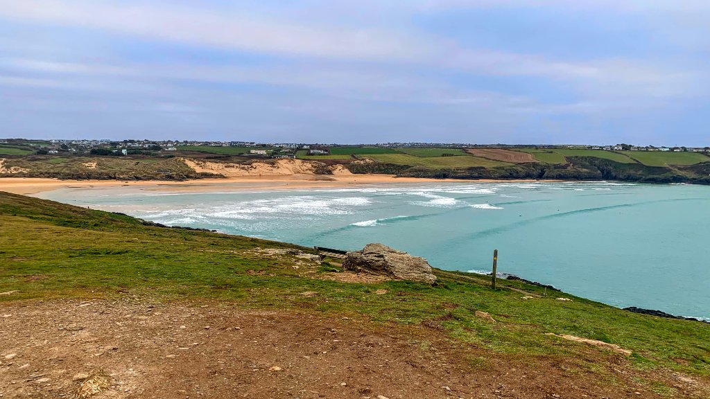
Crantock feels bigger than many Cornish beaches because the estuary opens the landscape wide. At low tide the beach stretches into reflective sand flats and winding tidal channels, while the dunes soften the edges of the bay. Even on busy summer days there is usually room to walk away from the crowds.
The Gannel Estuary is the defining geographical feature. It creates an unusual duality — part open Atlantic beach, part sheltered estuary channel, part dune system. The water changes character continuously with the tide, making Crantock more dynamic than a straightforward sandy bay.
In the evening, when the crowds thin and the Atlantic light drops low, the beach reveals its most compelling quality. The estuary reflections catch the sunset, the dunes cast long shadows, and the bay takes on a quality of stillness that summer afternoons rarely offer.
Current conditions & location
This night at Crantock Beach




Weather
☁️ Overcast
17°C (feels like 16°C)
Light breeze from the W
10% chance of rain
Today: 18°C / 12°C
Tides today
Today's tide at Crantock Beach is near low tide. For this beach, low to mid tide for families and surf. the estuary is fully open at low tide — good for paddling and sandcastle territory. at high tide the beach narrows significantly.. Conditions now are overcast, light breeze from the W, 17°C.
Met Office forecast updated every 30 minutes. Tide times are modelled estimates — confirm with local tide tables before swimming or crossing tidal ground.
Who Is This Place For?
Select your visit style to see what to expect.
Families
For families, Crantock works well at low tide when the beach is wide, the sand is soft and the estuary edges offer safe paddling territory for small children. The broad sandy areas away from the estuary channel are sheltered enough for relaxed family time. Be aware of the tidal cut-off across the Gannel if using the estuary path — check times before crossing.
Preparation
Useful for this beach
Based on what this location offers and what visitors typically find helpful.
Rockpooling
- Old trainers or beach shoes — rocks are slippery
- Small bucket for a closer look
- Best explored at or near low tide
Surfing
- Wetsuit appropriate to the season
- Board wax if you know the water temperature
- Towel or changing robe
- Check flag colours and tide before paddling out
Swimming
- Swim shoes if the seabed is rocky or shingly
- A warm layer for afterwards — wind chill is real here
- Dry bag to keep clothes off the sand
- Swim with others where possible
Photography
- Spare battery — cold and salt air drain them faster
- Lens cloth for sea spray
- Check the tide and light direction before you set up
Wildlife watching
- Binoculars if you have them
- Soft-soled footwear — quieter on rock and shingle
- Keep well back from nesting birds and resting seals
Water & Safety
Know Before You Go
Lifeguards
RNLI lifeguards patrol Crantock Beach seasonally, typically late May through September. Patrols operate between the red and yellow flags. Check RNLI website for current season dates and hours.
RNLI Information
Swim between the red and yellow flags when lifeguards are on patrol. Red flag means do not enter the water. If you see someone in difficulty, call 999 and ask for the Coastguard.
Rip Currents
Rip currents can form on either side of the beach, particularly near the dunes and estuary edges. If caught in a rip, do not swim against it — swim parallel to shore and signal for help. Strong swimmers should be aware of shifting conditions.
Tidal Hazards
The Gannel Estuary creates significant tidal cut-offs. The footbridge across the Gannel can be submerged at high tide, cutting off the inland path back to Newquay. Check tide times before using the estuary crossing. Tidal channels can form quickly across the lower beach.
Safe Swimming Areas
The safest swimming is in the flagged area between the red and yellow flags. The open sandy areas of the main beach are generally safer than the estuary edges. Avoid swimming near the estuary channel when tidal flow is active.
Safety Summary
Check tide times before visiting — the Gannel Estuary significantly changes the beach and access conditions. Swim only between the flags when lifeguards are present. The beach can become very busy in summer, which increases the importance of flag awareness.
Seasonal Character
Through the Seasons
Summer brings families and surfers in quantity — the beach is at its busiest from late July through August, and the car park fills early. The lifeguards are on patrol and the water is at its warmest, though Cornwall rarely exceeds 17 degrees. The estuary is at its most photogenic in the long evening light.
Autumn is when Crantock shifts character significantly. The crowds drop away, the swell increases and the beach takes on a rawer quality. The light becomes lower and longer, hitting the estuary and dunes in ways that summer cannot match. October and November can produce genuinely spectacular conditions.
Winter makes Crantock feel like a different place. The wide sand flats are often empty except for dog walkers. Atlantic storms deliver serious wave energy to the beach, and the drama of a westerly gale rolling in across the bay is something that summer visitors rarely see.
Spring sees the dunes come to life — wildflowers appear in the grassland and the bird activity increases around the estuary. The sea is still cold but the light is lifting and the beach is uncrowded.
Wildlife & Nature
Wildlife at This Location
The Gannel Estuary is the primary wildlife habitat at Crantock. Wading birds use the estuary margins at low tide — look for oystercatcher, curlew, and egret particularly in autumn and winter. The estuary channel holds mullet and other fish species visible from the banks.
The dune grassland supports a range of specialist flora including sea holly, sea bindweed, and various sedges. The dune system is a national habitat of conservation concern.
Rockpool areas at the edges of the beach hold the typical south-west Cornwall intertidal community — anemones, periwinkles, blennies, and various crabs. Early morning low tide exploration is most productive before disturbance increases.
Grey seals occasionally appear offshore and sometimes haul out on quieter sections of the beach, particularly outside the main summer season. Maintain respectful distance.
Community & Care
Who looks after this place
Volunteer groups
Crantock and the Gannel Estuary are cared for by several groups including the National Trust (who manage the car park and dune grassland), local beach clean volunteers, and estuary conservation efforts. The RNLI operates the seasonal lifeguard service from Newquay.
Beach cleans
Regular beach cleans take place at Crantock and neighbouring beaches throughout the year. The Cornwall Wildlife Trust and Surfers Against Sewage both run community clean events in the area. Check their websites and social media for upcoming dates.
Wildlife protection
The dune system at Crantock is a designated conservation habitat. Keep to paths through the dunes to avoid damaging the root structures that hold the dune system in place. During spring, some dune areas may have nesting birds — respect any temporary restrictions. The Gannel Estuary is a protected nature conservation area.
Community
Crantock village maintains a close relationship with the beach. The National Trust plays an important role in managing public access, parking revenue, and dune conservation. Local surf schools contribute to beach safety awareness.
Respecting this place
Keep to designated dune paths — the vegetation holds the entire dune system in place and is genuinely fragile. Take all litter home. If you see a seal on the beach, stay well back and keep dogs under control. Respect the RNLI flag system — it exists because local lifeguards understand the water conditions at this beach.
Photography
What to Photograph Here
The estuary reflections at low tide are the primary photography subject — particularly in the golden hour before sunset, when the sand channels hold reflections of the sky.
The dune system provides elevated shooting positions looking out across the bay, useful for wide landscape shots and for placing people in scale against the beach.
Sunset light hits the beach face-on from the west — Crantock is one of the better west-Cornwall beaches for classic sunset photography, with the estuary adding foreground interest that many pure surf beaches lack.
In autumn and winter, incoming Atlantic swells make for powerful wave photography. A telephoto lens from the dune crest allows safe distance while capturing wave detail.
Early morning mist over the estuary can create atmospheric shots in spring, particularly when the beach is empty.